


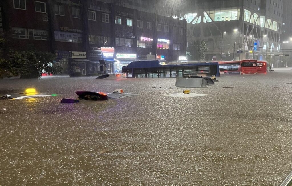
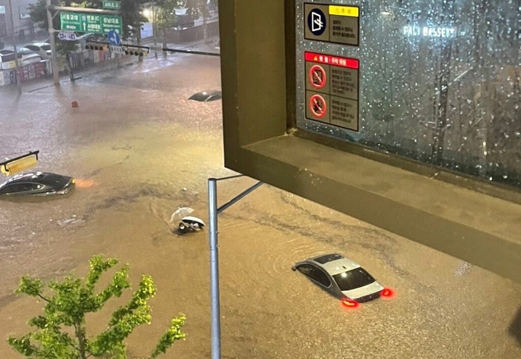
Record heavy rains in about 80 years have caused damage throughout Seoul.Heavy rains of more than 50 millimeters to 100 millimeters per hour are now causing flooding in the central part of Seoul and surrounding satellite cities.Seoul Water Circulation Planning Officer in 2015: Currently, Seoul aims to prepare for 30 years of frequency rainfall, up to 95mm (per hour) and up to 100mm.The Seoul Metropolitan Government is confident that it can handle heavy rain that can come about once every 20 years.There was another flood of water, overshadowing this boast.On the afternoon of the 8th, the area around Gangnam Station in Seoul was reminiscent of a “disaster site.” Heavy rains of more than 110mm per hour caused sewage to flow back and flooded roads in an instant. Cars driving nearby stopped helplessly, and some drivers fled in a hurry, leaving their cars intact. Seocho-gu and Gangnam-gu, near Gangnam Station, which have been regularly flooded every time of heavy rain since 2010, have suffered enormous flooding this time, and Seoul’s water defense and dimensional management has once again been under fire.Based on the explanation of the Korea Meteorological Administration on the 9th, the cause of the rain is briefly summarized, “Cold and dry air coming down from the north and warm and humid air coming up from the south met to create a gridlock in the central part of Korea.”When asked why cold and dry air moves south, the answer is “Because high-pressure power is located in the Okhotsk Sea east of Korea.” High pressure blocked the east-west flow of the atmosphere like a wall, and the cold and dry air in the north came down a lot from Korea to the south.It is estimated that the large amount of precipitation was affected by the recent influx of water vapor from the low latitudes to the mid-latitudes to which Korea belongs.Last night’s water bomb in southern Seoul was caused by a narrow rain cloud that hit the cold, dry air in the north and hot and humid air in the south harder than before after a wide rain cloud fell to the east in central Seoul on the 8th.
The rain cloud was so narrow that it could not cover Seoul that when it rained more than 140mm per hour in Dongjak-gu, it rained only about 20km away in Dobong-gu.
To the question of why rain clouds span southern Seoul, it is difficult to answer except for the explanation that “two air with different properties formed a balance of power there.”When asked whether the root cause of this torrential downpour is climate change or whether this torrential downpour should be viewed as one of climate change, it is not easy to answer at present.Academics point out that the pattern of precipitation in summer, including the rainy season, is changing.
From 1970 to the early 1990s, as the word rainy season means, after a long period of rain, the heat wave appeared after the rain, and from the mid to late 1990s, it sometimes rains a lot before and after the formation of the rainy front.During this year’s rainy season, “Fall rain → Heat wave → Heavy rain” continued.In the past, the stagnant front, which is close to a straight line, rained in the order of “central → southern” or “south → central” for a long time, but recently, the stagnant front, which is bent like a wave, poured down all over the country, and then rained again.The change in the expansion of high pressure in the North Pacific is cited as the reason, but it is not clear why the change has occurred.Of course, there is an analysis that the precipitation pattern has not changed during the rainy season.The Institute of Basic Science (IBS) Climate Physics Research Group released a study in 2020 that showed the longest rainy season ever, saying, “There was no clear long-term change in average precipitation and extreme precipitation values on the Korean Peninsula from 1973 to 2020.”
It is estimated that abnormal temperatures in the Arctic affected the rainy season in 2020, but the research team said, “The statistical and physical basis is weak,” and pointed out, “It is very difficult to prove that warming over the past decades is closely linked to a single extreme phenomenon (like the rainy season).”Eun Chul-jang, a professor at Gongju University, said, “To say that the pattern of the rainy season has changed, it should be ‘the game has changed,’ but it is difficult to say so,” adding, “It is a situation where annual volatility is greater than that.”There is virtually no disagreement that climate change will exist and climate change will affect Korea’s precipitation, even if there are differences on whether or not the precipitation pattern has changed in summer.The IBS Climate Physics Research Group also said, “Warming is real,” adding, “If greenhouse gas emissions are not greatly reduced, precipitation in the summer of the Korean Peninsula will increase by 10 to 15 percent in 2100.The Korea Meteorological Administration (KMA) and the Asia-Pacific Economic Cooperation (APEC) Climate Center (APEC) released extreme precipitation forecasts in June following the carbon emission scenario.According to the forecast, when the “High Carbon Scenario” (SSP5-8.5), which assumes that carbon is emitted as much or a little more than the present, is applied, the “100-year frequency of extreme precipitation” increases by about 29% in the first half of this century (2021-2040).
The 100-year extreme precipitation frequency is 187.1~318.4mm based on the current accumulated precipitation (2000~2019), which will increase by 21.4~174.3mm in the first half of this century.The 100-year frequency of extreme precipitation is calculated using the probability distribution, meaning “the amount of precipitation that will appear once in 100 years.”
KS CHOI
ASIA JOURNAL
